I’ve been Working on the Railroad
Friday, June 23rd, 2006 10:23 am by NealHR has taken his love of the Appalachian mountains in general to specialize in studying her railroads. The history of the Appalachian railroads combines engineering, geology, geography, war, and the will of the men who endeavored to conquer steep, tortuous terrain in order to connect the resources of the midwest (and the coal of West Virginia and Kentucky) to the areas of commerce like Atlanta and Charleston (with her seaports). HR has this report and link to a fascinating article from a Scientific American circa 1900 entitled The Costliest Railroad in America.
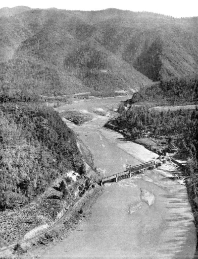 |
| Bird’s Eye View of Unaka Springs, Tenn., on the new Carolina, Clinchfield & Ohio Railway |
Let’s start with HR’s report:
I went to see the Stumphouse Tunnel near Walhalla SC last Saturday which was intended to be a mile long tunnel that would allow a railroad to get up and over the Blue Ridge escarpment by going under the last big mountain at the top of the escarpment. If the rail line could make it to the top then it could twist around and utlitmately follow along the path of the Little Tennessee river through the mountains before turning north to Knoxville.
The goal was to build a railroad from Charleston to Cincinnati that went through the southern mountains so as to connect a southeastern port directly to the midwest by rail. Construction on this rail line started in 1850. but by 1859 the company went broke although they had completed a large part of the railroad grade including some other tunnels. Stumphouse stumped them though, and the tunnel was never completed despite huge effort. At one time a town of 1,500 existed just to support the tunnel labor gangs who only had hand tools and black powder to dig through a mountain of granite. After the War Between the States no one could re-orgainize a company to complete the job.
The rail line that went up the Saluda grade on the way to Asheville on the French Broad river was another answer to the problem of getting a railroad over the escarpment. The engineers at Saluda chose to create the steepest grade on any US railroad instead of tunnelling.
On the other hand the Southern rail line at Toccoa GA manages to climb on the escarpment without tunnels or excessive grades, but it has the highest trestle of any railroad east of the Mississippi in order to jump over the gorge created by the North Fork of the Broad River as it has cut its way down into the edge of the escarpment.
Atlanta exists where it does in large part because it is at the point where railroads could make a turn around the end of the mountains avoiding the worst of the steep terrain and head northwest from the southeastern US.
Finally consider the Clinchfield Carolina rail line from Johnson City TN to Marion NC and Spartanburg SC which is the subject of the following link:
http://www.catskillarchive.com/rrextra/stclin.Html
This Scientific American acticle from 1900 calls it the The Costliest Railroad in America. It’s main purpose was to carry coal from the mines in Kentucky and West Virginia to Charleston where it could be carried by ships. This is railroad is a work of brute force construction designed to carry the heavily loaded coal cars. Bridges and steep grades were avoided while land filling and tunneling were preferred. At one point the line makes an eight mile loop to come back within 400 yards of itself just to climb 300 feet in
altitude.
Here’s the introduction to the article, The Costliest Railroad in America:
This is the story of a great railroad. It is the Carolina, Clinchfield & Ohio Railroad, just completed from the great bituminous coal fields of southwestern Virginia and eastern Kentucky to the cotton mill district in South Carolina. The promoter and builder of this magnificent road is George L. Carter. To-day it stands as a monument to his genius—one of the greatest pieces of railroad construction east of the Rocky Mountains.
It is the only road which crosses the entire Alleghany Mountains at their widest part transversely, or at direct right angles with their parallel ranges. Rising from a few hundred feet above the level of the sea to 2,629 feet, at the highest point, where it crosses the Blue Ridge Mountains, exceptionally low grades have been maintained. From Dante, Va., the present northern finished point, to Bostic, N. C., its present southern terminus, the distance is 211 miles; and for the distance it contains more tunnels than any other road in the country. There are thirty-five tunnels, six important bridges, and many very large cuts and fills; but in the main, bridges and trestles have been done away with, and wherever possible, replaced by fills.
Take a map showing eastern Kentucky, southwest Virginia, eastern Tennessee, and western North Carolina; then locate Elk Horn City in Pike County, Kentucky, near the Virginia line, which is the nearest town of any size to Dante, Va.; next draw a straight line through to Marion, N. C., via Johnson City, Tenn., and you have the route of the C., C. & O. Railroad—directly across more mountain ranges than any other section in the Alleghany system.
The purpose of the road is to furnish an outlet for the product of the Clinchfield coal mines, principally to the southeast Atlantic seaboard, nearest the Panama Canal and southern coaling stations.
Read on for a truly fascinating article on a piece of Eastern US history with many, great black-and-white photos. And, a big THANKS! to HR.